


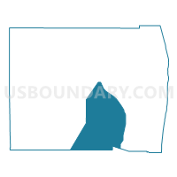
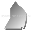
NP16-Voting District, Palm Beach County, Florida
About
Outline

Summary
| Unique Area Identifier | 557495 |
| Name | NP16-Voting District |
| County | Palm Beach County |
| State | Florida |
| Area (square miles) | 288.08 |
| Land Area (square miles) | 287.07 |
| Water Area (square miles) | 1.01 |
| % of Land Area | 99.65 |
| % of Water Area | 0.35 |
| Latitude of the Internal Point | 26.50514450 |
| Longtitude of the Internal Point | -80.33654080 |
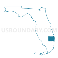
Maps

Graphs
Select a template below for downloading or customizing gragh for NP16-Voting District, Palm Beach County, Florida


Neighbors
Neighoring Voting District (by Name) Neighboring Voting District on the Map
- 3082-Voting District, Palm Beach County, FL
- 3084-Voting District, Palm Beach County, FL
- 5002-Voting District, Palm Beach County, FL
- 5042A-Voting District, Palm Beach County, FL
- 5042B-Voting District, Palm Beach County, FL
- 5094B-Voting District, Palm Beach County, FL
- 5102-Voting District, Palm Beach County, FL
- 5106-Voting District, Palm Beach County, FL
- 5122-Voting District, Palm Beach County, FL
- 5130-Voting District, Palm Beach County, FL
- 5131-Voting District, Palm Beach County, FL
- 6038-Voting District, Palm Beach County, FL
- 6040-Voting District, Palm Beach County, FL
- 6134-Voting District, Palm Beach County, FL
- 6141-Voting District, Palm Beach County, FL
- EVERGL-Voting District, Broward County, FL
- Q040-Voting District, Broward County, FL
- Q044-Voting District, Broward County, FL
Top 10 Neighboring County Subdivision (by Population) Neighboring County Subdivision on the Map
- Sunshine Parkway CCD, Palm Beach County, FL (187,746)
- Deerfield Beach CCD, Broward County, FL (173,967)
- Glades CCD, Palm Beach County, FL (517)
- Conservation CCD, Broward County, FL (20)
Top 10 Neighboring Place (by Population) Neighboring Place on the Map
Top 10 Neighboring Unified School District (by Population) Neighboring Unified School District on the Map
Top 10 Neighboring State Legislative District Lower Chamber (by Population) Neighboring State Legislative District Lower Chamber on the Map
- State House District 85, FL (193,827)
- State House District 101, FL (189,600)
- State House District 97, FL (169,848)
- State House District 78, FL (156,153)
Top 10 Neighboring State Legislative District Upper Chamber (by Population) Neighboring State Legislative District Upper Chamber on the Map
- State Senate District 27, FL (551,555)
- State Senate District 39, FL (483,183)
- State Senate District 30, FL (458,703)
- State Senate District 32, FL (428,898)
Top 10 Neighboring 111th Congressional District (by Population) Neighboring 111th Congressional District on the Map
- Congressional District 16, FL (797,711)
- Congressional District 19, FL (736,419)
- Congressional District 23, FL (684,107)
Top 10 Neighboring Census Tract (by Population) Neighboring Census Tract on the Map
- Census Tract 77.13, Palm Beach County, FL (11,296)
- Census Tract 105.03, Broward County, FL (11,237)
- Census Tract 79.12, Palm Beach County, FL (9,228)
- Census Tract 77.53, Palm Beach County, FL (8,099)
- Census Tract 77.30, Palm Beach County, FL (6,493)
- Census Tract 77.35, Palm Beach County, FL (5,689)
- Census Tract 77.21, Palm Beach County, FL (4,944)
- Census Tract 77.48, Palm Beach County, FL (4,842)
- Census Tract 77.59, Palm Beach County, FL (1,891)
- Census Tract 9800, Broward County, FL (20)
Top 10 Neighboring 5-Digit ZIP Code Tabulation Area (by Population) Neighboring 5-Digit ZIP Code Tabulation Area on the Map
- 33414, FL (53,718)
- 33428, FL (38,548)
- 33076, FL (29,751)
- 33470, FL (26,551)
- 33067, FL (26,458)
- 33472, FL (19,100)
- 33498, FL (14,557)
- 33449, FL (10,817)